_edited.png)

Geospatial & Survey Support
Drone LiDAR, Photogrammetry, and CAD-Ready Deliverables for Engineers, Utilities, and Surveyors
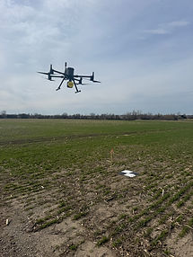
SkyFleet partners with survey and engineering teams to collect LiDAR and photogrammetry data and deliver it as CAD-ready surfaces, contours, and orthophotos — built around your software and workflow, ready to use on day one. Our NDAA-compliant drone fleet can support any project requirements, including government, utility, and telecom contracts.
100+
Projects Delivered
2,000+
Cell Tower Inspections
100+
Topographic Surveys

Our Approach
At SkyFleet Solutions, our goal is to help survey, engineering, utility, construction, and telecom teams collect better data and turn it into usable deliverables faster.
We understand that every project is different. Some clients need full-service data collection and processing, while others already have drones in-house and only need help turning large datasets into clean CAD or GIS-ready files. That’s why we tailor our approach to fit each client’s workflow, deliverable requirements, timeline, and level of in-house experience.
Our team supports both experienced firms that already use drone technology and teams that are just starting to bring LiDAR, photogrammetry, bathymetry, or inspection workflows into their projects. Whether we are collecting the data in the field or processing data you already captured, our focus stays the same: accurate results, efficient workflows, and deliverables that are actually ready to use.
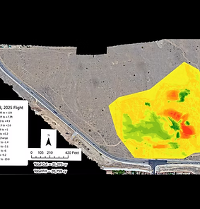
We do not just provide raw drone data. We help turn field data into practical outputs such as CAD-ready surfaces, contours, orthophotos, classified point clouds, feature-coded datasets, PLS-CADD-ready files, GIS deliverables, bathymetric models, and inspection documentation.
From the first conversation, we work to understand what you need the data for, how your team plans to use it, and what format will make the deliverables easiest to bring into your existing workflow. This helps reduce unnecessary file sizes, avoid rework, and make sure the final product is built around the end use.
Our approach is simple: understand the project, collect or process the data correctly, and deliver clean, accurate information that helps your team move forward.
OUR SERVICES


.png)
Accurate Aerial Data, Simplified for CAD Integration
Most drone companies deliver photos, videos, or oversized raw point clouds that slow down your CAD. SkyFleet delivers survey and engineering-ready data. We clean, thin, classify, and format every dataset around the end use — so the files you receive drop straight into your workflow without the rework.

Whether you need full-service data collection, processing-only support, or overflow capacity for large sites and corridor projects — SkyFleet fits into your process. SkyFleet operates an NDAA-compliant drone fleet, making us ready to support government contracts, utility work, and any project with specific compliance requirements.
Ready to Start Your Next Project?
Tell us about your site, your software, and your deliverable requirements. SkyFleet will build a workflow around your team's needs.

Clients & Partners


About Us
SkyFleet Solutions was founded in 2021 by Gage Uhlman and Devin Hartpence with the goal of bringing high-accuracy drone data into everyday engineering, surveying, and construction workflows. Built on a background in geospatial technology, aviation, and real-world field operations, SkyFleet was created to close the gap between traditional surveying methods and modern aerial data capture. From the beginning, the company has focused on delivering reliable, CAD ready products that help clients move faster, reduce field time, and make better decisions using accurate, up to date site data.

Our Team


GET IN TOUCH
Inquiries
Careers
For inquiries, questions, or feedback, feel free to contact us at (515) 513-9625, email office@skyfleetsolutions.com, or fill out the form below. We’re here to provide professional support and ensure your needs are met.
Offices: Des Moines, IA & Charleston, SC
Join our team of dedicated professionals and contribute to our mission of excellence. Submit your resume and cover letter to office@skyfleetsolutions.com to explore rewarding career opportunities in our dynamic organization. To be a 1099 contractor fill out our pilot form below on the Skylfeet pilot portal.